
Walking tour – page 4
Opposite the pub and main entrance to the Castle is:
![]() Point 8, Castletown Police Station, with its distinctive conical roof. It was designed by the increasingly highly regarded Arts and Crafts architect M H Baillie Scott, who allegedly came to the Island for a holiday but set up in practice as he could not face the boat crossing back!
Point 8, Castletown Police Station, with its distinctive conical roof. It was designed by the increasingly highly regarded Arts and Crafts architect M H Baillie Scott, who allegedly came to the Island for a holiday but set up in practice as he could not face the boat crossing back!
To the right of the police station is the public entrance to Castle Rushen; as previously mentioned you should allow at least an hour for a visit. The tall windows high above the curtain wall are of Derby House, which in the 17th, 18th and early 19th centuries was the residence of the Island’s Governor.
 Walk along the quay, towards the sea. Part of the long white building on your right was formerly the Castletown office of the Isle of Man Steam Packet Co. A little way beyond is a tall warehouse, now called the Granary; notice the lintels which are of Pooilvaaish marble.
Walk to the end of the quay, which is:
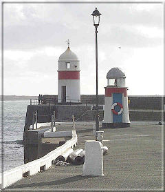
![]() Point 9. You will see the breakwater with the small lighthouse on the end which bears the inscription “VR 1849”. Castletown harbour has always been difficult to enter and in Norse and later times many visitors landed at Derbyhaven, a couple of miles to the east. The Herring Tower, the large stone tower on Langness across the bay, was built as a shipping mark in 1811, and the lighthouse on the end of Langness followed in 1880. A little way on your right is the old Lifeboat House, closed in 1922, since when the Douglas and Port St Mary lifeboats have served this stretch of coast.
Point 9. You will see the breakwater with the small lighthouse on the end which bears the inscription “VR 1849”. Castletown harbour has always been difficult to enter and in Norse and later times many visitors landed at Derbyhaven, a couple of miles to the east. The Herring Tower, the large stone tower on Langness across the bay, was built as a shipping mark in 1811, and the lighthouse on the end of Langness followed in 1880. A little way on your right is the old Lifeboat House, closed in 1922, since when the Douglas and Port St Mary lifeboats have served this stretch of coast.
Castletown remains, albeit on a small scale, a working harbour; coal is brought in and scrap metal exported. In the 1960’s and 1970’s there was container traffic, the containers initially transported on the steam railway.
 Head back into the town up the narrow Parliament Lane to:
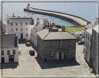
![]() Point 10, the back of Parliament Square. During the Civil War, when Lord and Lady Derby held the castle for the King, Parliament Square was cleared of the houses which formerly covered it to give a better range of fire for the cannon in the castle.
Point 10, the back of Parliament Square. During the Civil War, when Lord and Lady Derby held the castle for the King, Parliament Square was cleared of the houses which formerly covered it to give a better range of fire for the cannon in the castle.
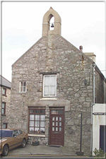
On your right is the Rocket House, formerly the seat of the Castletown Volunteer Rocket Brigade, with a bell to summon members to assist ships in distress.
On your left is probably the finest early Georgian building on the Island, 2 Parliament Square. Notice especially the fanlight and doorcase, and the cannon, used as a hitching post, by the steps.
Walk past the front of 2 Parliament Square into the car park which, until its clearance in the 1950’s, contained the oldest part of the town, Chapel Lane and School Lane.
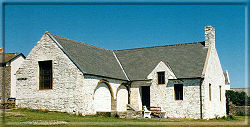 The building sitting forlornly in the middle is the Old Grammar School, built in the 13th Century as St Mary’s Chapel and the town’s church until 1698.
It then became the Castletown Grammar School until 1930 and is now a tourist information centre and small museum.From here you can see the full sweep of the bay. On the right is Scarlett; the large rock, cut off at high tide, is the Stack, the remains of an extinct volcano.
With your back to the sea, leave the car park by the exit which is in front and slightly to the right of you, and follow the signpost marked Castle Rushen passing between the houses on the left and a square stone building on the right.
 Return to Point 10 in Parliament Square, so called because the square building was formerly the meeting place of the House of Keys, the lower house of the Manx Parliament. When the House of Keys finally moved to Douglas in 1874, Castletown ceased to be the Island’s capital.
In front of Compton’s Restaurant are some of the few remaining cobbles in the town.
Now turn left up Castle Street, noting some more fine shopfronts and also the attractive Georgian fanlight above the front door of Stanley House next to the Manx Electricity Authority.
You have returned to the Market Square where this short walk began. It is hoped that the visitor who has time will be tempted to further exploration of the old town and its environs.
![]()
![]()